
Upper Applegate Watershed Restoration Project
The planning process for the UAW project was a unique collaborative approach between stakeholders and federal agencies that incorporates an all-lands approach to address landscape resilience to disturbance—especially wildfire—and climate change. It reflects the need for forest restoration work in the Applegate Adaptive Management Area that the community has envisioned for decades. With funding from Oregon Watershed Enhancement Board (OWEB) and additional sources, the Rogue Forest Partners are excited to put years of planning and conversation with the community into action.
Where:
When:
Ecological thinning began in June 2021. Further treatments are scheduled through 2024.
Why:
Acreage is strategically prioritized for treatment to mitigate wildfire risk and enhance wildlife habitat.
Scope:
18,000 acres to be treated (out of a 52,000-acre focus area)

Restoration Timeline
For the first phase, Lomakatsi Restoration Project developed restoration prescriptions and marked treatment areas on 273 acres near Beaver Creek, partnering with the USFS, BLM, and other partners. Their crews began ecological thinning there in June 2021, with controlled hand pile burning scheduled for within a year as conditions allow.
The second phase will treat 1,100 acres selected based on proximity to adjacent communities and strategic ridgelines, connectivity to recent and proposed thinning and prescribed fire treatments on federal land, the prevalence of strategic ridgelines within units, and proximity to existing primary roads. Lomakatsi completed the layout and prescriptions for this second phase, with work to begin in Fall 2022. Further treatments under OWEB funding are scheduled through 2024, and additional acres of restoration will be accomplished within UAW from additional funding sources.
Restoration Objectives
Several hundred homes in the project area are currently at risk of damage from wildfire. The restoration work in the project area will significantly reduce that risk to communities and the ecosystem and improve forest health, building resistance to disease, and protecting ecosystem services—the many and varied benefits to humans provided by the natural environment and from healthy ecosystems. Combining handwork and prescribed burning will reduce stand competition, improve forest structure, and reduce wildfire severity.
The project is located within the Applegate Adaptive Management Area (AMA) designated by the Northwest Forest Plan. Areas under this designation are encouraged to use collaboration and forward-thinking processes during project planning to improve the capacity for local community problem-solving across boundaries; to use resources efficiently; to share knowledge freely and effectively; and to use adaptive management principles of testing, monitoring, and learning, and share this learning with all partners.
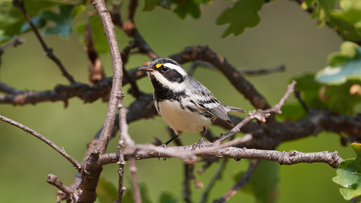
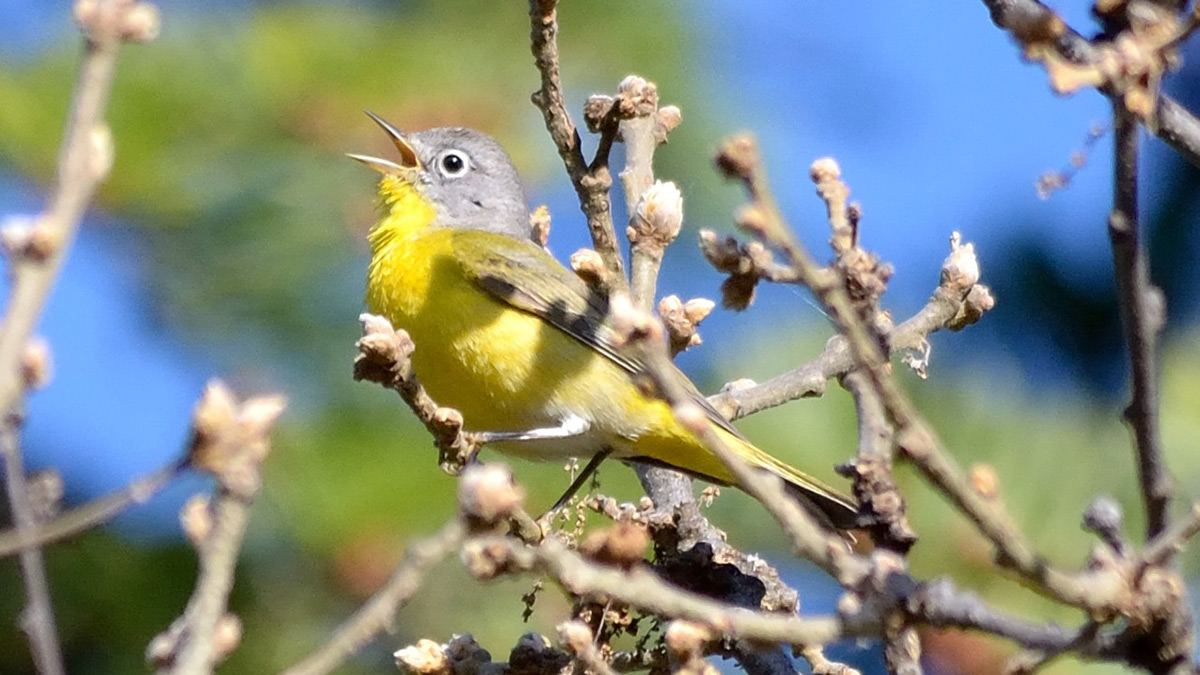
UAW is part of Rogue Forest Partner’s robust multi-party monitoring framework. One key component, led by the Klamath Bird Observatory, is bird monitoring. Bird populations are a good indicator of forest health. Survey data show that measuring birds’ response to restoration provides a more meaningful and multidimensional assessment of restoration success than traditional vegetation metrics alone.
The Rogue Basin communities, woodlands, and forests are at risk of uncharacteristic fire and no one organization can manage this risk. The Rogue Forest Partners share a common vision, seeking to restore forests and reduce risk by applying ecological restoration and bringing fire back as a tool.
Terry Fairbanks, Southern Oregon Forest Restoration Collaborative
RFP has identified six projects across the Rogue Basin. These high-priority areas, spanning public land and private tracts, are critically important for reducing the risks of extreme wildfires, promoting forest health, and restoring resilience to our landscape. The work began in the Applegate and Illinois Valleys in 2020 and continues into 2025.
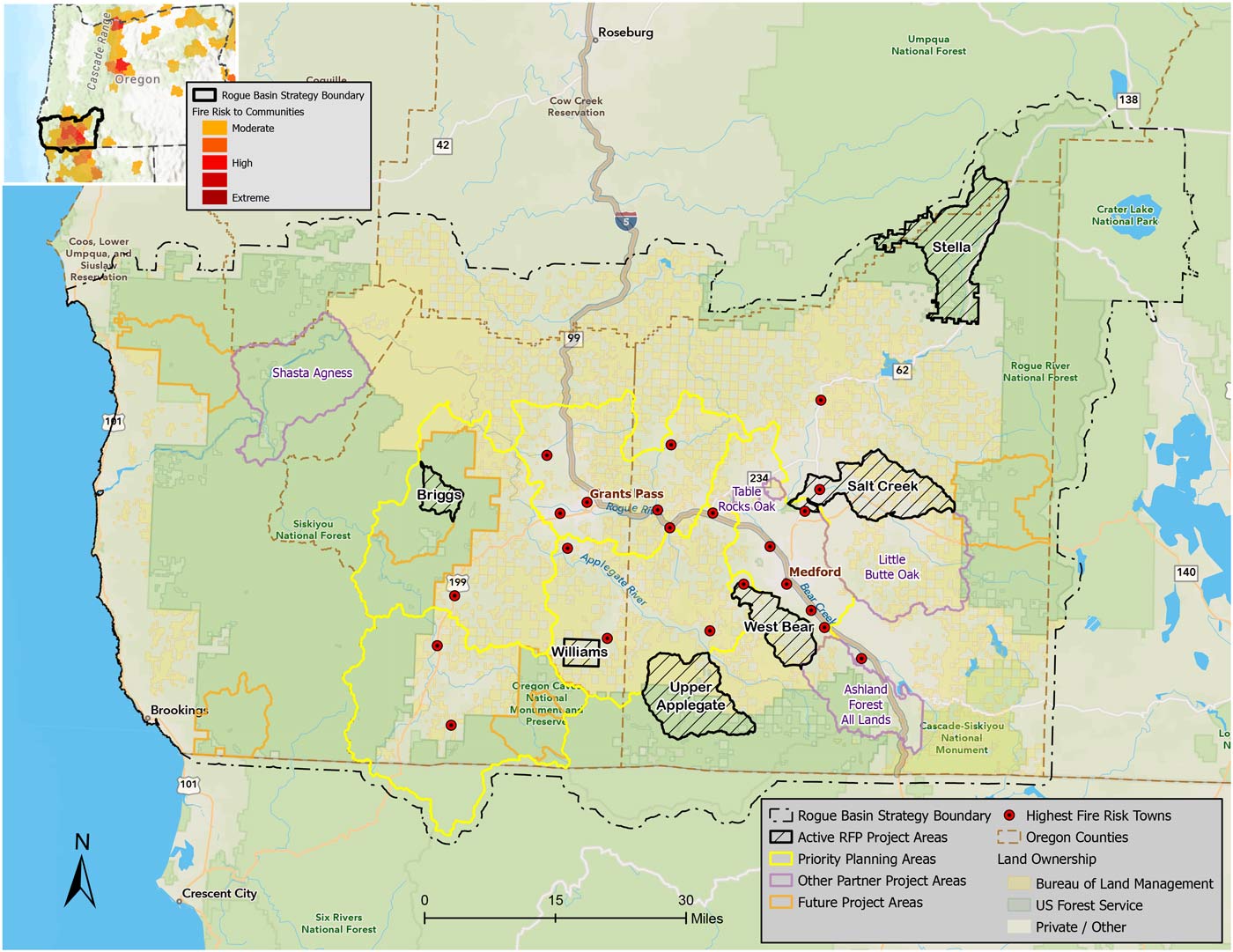
The Upper Briggs Restoration Project on the Wild Rivers District in the Illinois Valley supports diverse habitats and forest conditions. This ridge burned in the Klondike/Taylor fire, but from ridge to stream, one encounters legacy trees to protect, dense understories to be thinned and chaparral patches intermixed. The ridgeline is important for managing fires moving from wildlands toward Illinois Valley communities.
The Williams Project near the community of Williams in Josephine County is focused on reducing fuels and improving forest habitat through restoration treatments on federal and private lands in an all-lands effort bringing together the BLM and NRCS with the RFP to demonstrate restorative wildfire risk reduction. Together, we are working toward the landscape-vision of the RBS.
The West Bear Project addresses the need for wildfire fuels reduction immediately adjacent to the cities of Jacksonville, Phoenix, Talent, and Medford. The 27,000-acre project area within the wildland urban interface west of Bear Creek and the I-5 corridor is one of the most at-risk locations for wildfire in Oregon.
The 50,000-acre USFS and BLM Upper Applegate Watershed Project (UAW) is located in the Applegate Valley with over 18,000 acres of planned restoration treatments designed during a three-year community planning process convened by the Siskiyou Mountains Ranger District of the RRSNF. Some 3500 acres are scheduled by RFP to be completed by 2025. The UAW is one of the highest priority areas for restoration under the RBS.
The Stella Landscape Restoration Project project occurs in the most productive corner of the Rogue Basin, where the lack of low-intensity fire and past management has resulted in high-density stands and declining forest health. To improve wildlife habitat and forest health and build ecosystem resilience to wildfire, the Stella Project will strategically apply ecological thinning (both non-commercial and commercial) and prescribed fire to achieve restoration goals across a 43,955-acre footprint.
The Salt Creek Project planning area is large but RFP work with the BLM starts with a small footprint of fuels treatments in oak woodlands. The treatments will demonstrate ecological restoration under the RBS in these dry but diverse oak habitats and help reduce wildfire risks near the communities of Eagle Point.